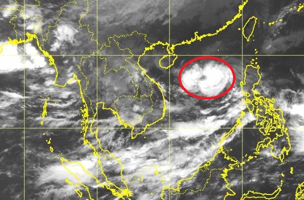
열대폭풍 "우딥" 주의
태국 기상청은 27일 오후 4시 30분 남 중국해에서 발생한 열대저기압이 열대성 폭우로
발전하여 이에 따른 경보를 발령했습니다.
중부, 북부, 북동부, 동부 4개 지역의 23개 지방에 대하여 주말 많은 비가 예상 된다고 관측했습니다.
| Advisory "Tropical Storm “WUTIP”" No. 1 Time Issued : September 27, 2013 | ||
| At 1.00 p.m. LST on 27 September, the tropical depression over the middle South China Sea has upgraded to the tropical storm “WUTIPW” and at 4.00 p.m. LST today, was centered about 950 kilometers east of the coastal areas of Vietnam or at 17.3 degree North and 115.8 degree East with maximum sustained winds about 65 km/hr. It is moving west at speed of 10 km/hr. It is expected to strengthen as a tropical storm move near the coastal areas of Vietnam during 30 September – 1 October. More rain and isolated heavy rain is likely in the eastern part of northeastern Thailand during the period. The rather strong high pressure from China remains over upper Thailand affecting the monsoon trough across the lower North, the upper Central and the Northeast. It is expected during 28-29 September the trough will lie across the lower Central and the East leading to torrential rain with isolated heavy rain in the following provinces: Phichit, Phetchabun, Roi Et, Nakhon Ratchasima, Buri Ram, Surin, Si Sa Ket, Ubon Ratchathani, Nakhon Sawan, Uthai Thani, Lop Buri, Saraburi, Nakhon Nayok, Prachin Buri, Sa Keao, Chanthaburi and Trat. People should beware of the severe weather during this period. The advisory will be effect on 27 September 2013 at 4.30 p.m. (Signed) Worapat Tiewthanom (Mr Worapat Tiewthanom) Director-General, Thai Meteorological Department |


